- Posts
- 14,902
- Location
- Doncaster
Green Lanes
finding them!!
So youve got the Landrover and you want to use it, but where to go?
Theres a bit of preparation required, I wont discuss the Landy prep as thats covered elsewhere, but preparation for finding, and making sure theyre legal, green lanes to drive.
First step get an Ordnance Survey map of your area. 1:25k is best, 1:50k is also very useful as an overall and quick guide. Get yourself familiar with the main OS key (slightly different for each map scale, particularly the keys for roads of all types below A or B road status. Not all green lanes are byways, some cracking lanes can be had by following up unclassified roads.
So, Key 1, the Explorer 1:25k, Orange coloured paper maps. Were only interested in roads and rights of way at the moment.
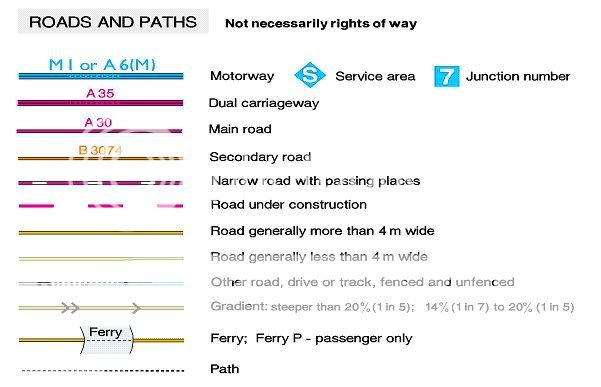
So look at the map, we can mostly discount the Motorway system and A & B roads as only being useful to get somewhere, the roads and tracks we need to look for are

All of which can be useful to us, especially the unfenced roads as they are also sometimes single-track, un-kept and can be really quite rough .. just what we want!
However, the real green-lanes are amongst the following.
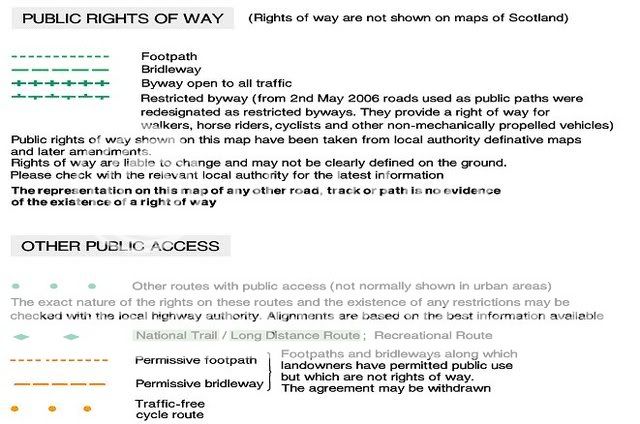
The lanes of interest to us are the boats. Byway open to all traffic.
Restricted Byways (formerly rupps) are supposedly of no use (legally) for vehicular use any more, but more of that later. We CANNOT drive on footpaths or bridleways, end of ! Unfortunately many footpaths and bridlepaths are obviously used by 4x4s (or vehicles at least) but local farmers are likely to have an agricultural easement for access to use these, so just because theyre allowed to doesnt mean we can!
The 'other public access' routes are also useful in that many long distance rights of way are open to vehicles, such as Peddars Way in Norfolk. Again, these are potentially interesting if there's one near you, but check it's legality first!
So, its the lines of green crosses that denote the lanes we can drive on. They are often un-kempt, scratchy, boggy/muddy and rutted as there are too few of them for the number of people who want to drive them. But they are the gold-dust we want")
So, what do they look like on a real map? How can we tell theyre legal, and how can we tell they might be interesting?
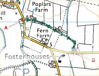
You can see the line of green crosses going from A to B or vice-versa. This is a Byway Open to All Traffic, a BOAT, and we can legally drive it. Indeed its close to my area and I know its also marked BYWAY with a proper signpost at each end.
I know its legal because Ive been onto the local councils website and searched their rights of way section where its named as a legal Byway and mentioned on the definitive map. Ordnance Survey get a lot of their information from the definitive maps so a lot of the time whats on the map should be OK to drive, but its worth checking first as a section 59 notice wont be a pleasant addition to your paperwork! To check legality you need to note the grid reference points at start and end of the lane, then either visit your local council website, phone the rights of way officer, or visit the council offices in person. Ive done all three of these to check lanes before and will continue to do so in future as Im a married man who has a wife and kids and I dont want to be taken to court by our draconian rights of way and justice system. (rant over!)
So how do we know its interesting? Well, we dont until we drive it, but some clues are there. Contour lines, the brown coloured squiggly marks. This area is flat, so anywhere with a couple of contours on it should at least have a little gradient or slope, OK, in this case its not much, but its there and is not far off the only place around with some. The little blue squiggly line running North to South at about 2/3rds across from the left is a river or stream, so potential for a ford or at least boggy ground. I this case its a bit boggy and while it looks innocuous enough, theres so much water about, even in hot weather, that the ground sinks under your wheels a little which can be a bit awkward and definitely gives you a queasy feeling. (Close to Hatfield and Thorne Peat Marshes)
Somewhere a bit more likely as a green lane that might be interesting, ie steep, boggy, whatever and why we dont totally ignore the Restricted Byway or RUPPs (Lines of green alternating Ts) until we know their legal status and why we have to speak with the local authorities
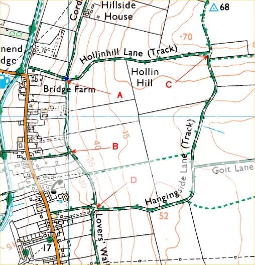
This is a really interesting set of lanes, all marked on the map as restricted byways but all the restricted bits are actually now BOATS on the Definitive Map and are also properly signposted as Byways ... an obvious example of maps not keeping up with the legal system and a good demonstration of the need to check legality. The lanes we cant legally drive are the bridlepaths, which are clearly visible between A and B, heading North from A and heading East near the L of Hangingside Lane and a couple of footpaths.
So, what makes this set of lanes look interesting on the map and worthy of following up?
First thing is the contour lines, the tracks are all on the side of a hill, going up it, traversing it, following contours and crossing contours. Theres a river at the bottom of the hill so the tracks heading West (ish) from A, B and D might be washed out with rainwater run-off from the hill and fields, theres a small valley toward the centre/east that one lane goes through. Lots of clues that its possibly an area worth looking at and worth taking some time and effort first to research the legalities, before driving out there, especially if as is my case, its quite far away.
In fact its a great area, the track heading East up the small valley to B, though only maybe 100 yards long is narrow, steep sided, washed out and is a minor challenge in itself, but most 4x4 drivers dont drive it!?!? Short but very sweet. Hangingside Lane is used far too much, probably because it is reasonably long, but its extremely rutted. It can be driven by standard Discos/Freelanders if care is taken to straddle ruts instead of trying to blast through. Care and technique wins over brute force here, but unfortunately you can't tell that from the map, so it needs to be driven out to and driven over to know!. The lane heading South from D is also a bit rutted and can easily catch people out, clay, mud, ruts and tree roots all combine to make it a bit of a challenge, with (which cant be seen on the pic) to the south a steep exit, blind onto an A road!
So thats it, that's in a nutshell what I look for on a map, spotting the clues to how good a lane might be, and what to do to check legality. Once you get into map-reading and relating the lines and colours on paper to the hills, lanes and other features of real life you also get to know all the other clues and map-reading becomes a bit like reading a book, you can actually seee the places in your mind way before you visit them!
I cant and wont take any responsibility for anyone using this information in any way, the above is what I do to find lanes, if you use it thats nice, but if you then drive illegally its nothing to do with me, I wasnt there, it was the other three .. OK
Have fun ..
So youve got the Landrover and you want to use it, but where to go?
Theres a bit of preparation required, I wont discuss the Landy prep as thats covered elsewhere, but preparation for finding, and making sure theyre legal, green lanes to drive.
First step get an Ordnance Survey map of your area. 1:25k is best, 1:50k is also very useful as an overall and quick guide. Get yourself familiar with the main OS key (slightly different for each map scale, particularly the keys for roads of all types below A or B road status. Not all green lanes are byways, some cracking lanes can be had by following up unclassified roads.
So, Key 1, the Explorer 1:25k, Orange coloured paper maps. Were only interested in roads and rights of way at the moment.
So look at the map, we can mostly discount the Motorway system and A & B roads as only being useful to get somewhere, the roads and tracks we need to look for are
All of which can be useful to us, especially the unfenced roads as they are also sometimes single-track, un-kept and can be really quite rough .. just what we want!
However, the real green-lanes are amongst the following.
The lanes of interest to us are the boats. Byway open to all traffic.
Restricted Byways (formerly rupps) are supposedly of no use (legally) for vehicular use any more, but more of that later. We CANNOT drive on footpaths or bridleways, end of ! Unfortunately many footpaths and bridlepaths are obviously used by 4x4s (or vehicles at least) but local farmers are likely to have an agricultural easement for access to use these, so just because theyre allowed to doesnt mean we can!
The 'other public access' routes are also useful in that many long distance rights of way are open to vehicles, such as Peddars Way in Norfolk. Again, these are potentially interesting if there's one near you, but check it's legality first!
So, its the lines of green crosses that denote the lanes we can drive on. They are often un-kempt, scratchy, boggy/muddy and rutted as there are too few of them for the number of people who want to drive them. But they are the gold-dust we want
So, what do they look like on a real map? How can we tell theyre legal, and how can we tell they might be interesting?
You can see the line of green crosses going from A to B or vice-versa. This is a Byway Open to All Traffic, a BOAT, and we can legally drive it. Indeed its close to my area and I know its also marked BYWAY with a proper signpost at each end.
I know its legal because Ive been onto the local councils website and searched their rights of way section where its named as a legal Byway and mentioned on the definitive map. Ordnance Survey get a lot of their information from the definitive maps so a lot of the time whats on the map should be OK to drive, but its worth checking first as a section 59 notice wont be a pleasant addition to your paperwork! To check legality you need to note the grid reference points at start and end of the lane, then either visit your local council website, phone the rights of way officer, or visit the council offices in person. Ive done all three of these to check lanes before and will continue to do so in future as Im a married man who has a wife and kids and I dont want to be taken to court by our draconian rights of way and justice system. (rant over!)
So how do we know its interesting? Well, we dont until we drive it, but some clues are there. Contour lines, the brown coloured squiggly marks. This area is flat, so anywhere with a couple of contours on it should at least have a little gradient or slope, OK, in this case its not much, but its there and is not far off the only place around with some. The little blue squiggly line running North to South at about 2/3rds across from the left is a river or stream, so potential for a ford or at least boggy ground. I this case its a bit boggy and while it looks innocuous enough, theres so much water about, even in hot weather, that the ground sinks under your wheels a little which can be a bit awkward and definitely gives you a queasy feeling. (Close to Hatfield and Thorne Peat Marshes)
Somewhere a bit more likely as a green lane that might be interesting, ie steep, boggy, whatever and why we dont totally ignore the Restricted Byway or RUPPs (Lines of green alternating Ts) until we know their legal status and why we have to speak with the local authorities
This is a really interesting set of lanes, all marked on the map as restricted byways but all the restricted bits are actually now BOATS on the Definitive Map and are also properly signposted as Byways ... an obvious example of maps not keeping up with the legal system and a good demonstration of the need to check legality. The lanes we cant legally drive are the bridlepaths, which are clearly visible between A and B, heading North from A and heading East near the L of Hangingside Lane and a couple of footpaths.
So, what makes this set of lanes look interesting on the map and worthy of following up?
First thing is the contour lines, the tracks are all on the side of a hill, going up it, traversing it, following contours and crossing contours. Theres a river at the bottom of the hill so the tracks heading West (ish) from A, B and D might be washed out with rainwater run-off from the hill and fields, theres a small valley toward the centre/east that one lane goes through. Lots of clues that its possibly an area worth looking at and worth taking some time and effort first to research the legalities, before driving out there, especially if as is my case, its quite far away.
In fact its a great area, the track heading East up the small valley to B, though only maybe 100 yards long is narrow, steep sided, washed out and is a minor challenge in itself, but most 4x4 drivers dont drive it!?!? Short but very sweet. Hangingside Lane is used far too much, probably because it is reasonably long, but its extremely rutted. It can be driven by standard Discos/Freelanders if care is taken to straddle ruts instead of trying to blast through. Care and technique wins over brute force here, but unfortunately you can't tell that from the map, so it needs to be driven out to and driven over to know!. The lane heading South from D is also a bit rutted and can easily catch people out, clay, mud, ruts and tree roots all combine to make it a bit of a challenge, with (which cant be seen on the pic) to the south a steep exit, blind onto an A road!
So thats it, that's in a nutshell what I look for on a map, spotting the clues to how good a lane might be, and what to do to check legality. Once you get into map-reading and relating the lines and colours on paper to the hills, lanes and other features of real life you also get to know all the other clues and map-reading becomes a bit like reading a book, you can actually seee the places in your mind way before you visit them!
I cant and wont take any responsibility for anyone using this information in any way, the above is what I do to find lanes, if you use it thats nice, but if you then drive illegally its nothing to do with me, I wasnt there, it was the other three .. OK
Have fun ..