suew
Well-Known Member
i came across this nice little track maybe a northwest meet as theres a few green lanes around lancs
I have checked this out with the local GLASS rep. Its NOT a legal route
P38dseGAV
Active Member
it says in clear signage its a BY WAYI have checked this out with the local GLASS rep. Its NOT a legal route
GRATCH
HUGE MEMBER
it says in clear signage its a BY WAY
Classifications have changed I think. By ways are not for vehicular access any more.
Someone with more knowledge will come along soon.
suew
Well-Known Member
From Trailwise
Geographical Details
Streetmap
Photos Start: SD 8056 1748 junction
GPS: N53°39.207', W2°17.736' End: SD 8057 1613 tarmac
GPS: N53°38.479', W2°17.722' Streetmap
Photos
Other Tracks which connect here : SD8016-01 Other Tracks which connect here :
SD8017-05 SD8017-06 SD8017-09
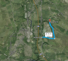
Edit GeographyMaps Google Map of Track
Historic Name: Bury Old Road
View/Edit Name/Definitions
Useability Track Useability
Restriction type : Other official restriction. Duration : Permanent.
Restriction Details view/edit/add
No info to suggest track is useable in any way
Update SurfaceGeneral surface description :- Made-up stone, hoggin or gravel
Add New FeatureNo track features recorded yet.
Geographical Details
Streetmap
Photos Start: SD 8056 1748 junction
GPS: N53°39.207', W2°17.736' End: SD 8057 1613 tarmac
GPS: N53°38.479', W2°17.722' Streetmap
Photos
Other Tracks which connect here : SD8016-01 Other Tracks which connect here :
SD8017-05 SD8017-06 SD8017-09
Edit GeographyMaps Google Map of Track
Historic Name: Bury Old Road
View/Edit Name/Definitions
Useability Track Useability
Restriction type : Other official restriction. Duration : Permanent.
Restriction Details view/edit/add
No info to suggest track is useable in any way
Update SurfaceGeneral surface description :- Made-up stone, hoggin or gravel
Add New FeatureNo track features recorded yet.
DIFFLOCK66
Well-Known Member
According to a quick look I've done on MARIO MARIO - Maps & Related Information Online
The part that's in Lancashire (the track does go outside the county boundary), is marked as a BRIDLEWAY. Please double check with LCC before driving, or recce it on horseback!")
EDIT - bridleway = green dotted line and labelled 14-3-BW-274
http://mario.lancashire.gov.uk/printing/_printA6BE8206139F471C808195DBCFE2B9FA.png
The part that's in Lancashire (the track does go outside the county boundary), is marked as a BRIDLEWAY. Please double check with LCC before driving, or recce it on horseback!
EDIT - bridleway = green dotted line and labelled 14-3-BW-274
http://mario.lancashire.gov.uk/printing/_printA6BE8206139F471C808195DBCFE2B9FA.png
Last edited: